thumbnail.png
From the dataset abstract
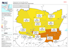
Map showing the food security classification (as of October 2020), as well as landslide threat (as of 16/11/2020) and population figures (2018) in each Municipality.
Source: Guatemala: Food Security and Landslide Threat in Alta Verapaz
Additional Information
| Field | Value |
|---|---|
| Data last updated | November 27, 2020 |
| Metadata last updated | November 27, 2020 |
| Created | November 27, 2020 |
| Format | PNG |
| License | License not specified |
| Has views | True |
| Id | e322e2ca-4f63-4e3b-b8f9-99cc9d3b1226 |
| Mimetype | image/png |
| On same domain | True |
| Package id | b97c29da-c4e0-4358-a69a-c4716f2f5696 |
| Position | 2 |
| Revision id | 3893c66b-347b-435d-b88c-a74c99a77278 |
| Size | 19.4 KiB |
| State | active |
| Url type | upload |