thumbnail.png
From the dataset abstract
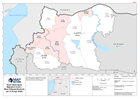
This map shows a situational overview the most affected districts in the North West of the Syrian Arab Republic.
Source: North West Syria Migration Crisis - Most Affected Districts (as of 28 Apr 2020)
Additional Information
| Field | Value |
|---|---|
| Data last updated | May 29, 2020 |
| Metadata last updated | May 29, 2020 |
| Created | May 29, 2020 |
| Format | PNG |
| License | Creative Commons Attribution |
| Has views | True |
| Id | 8da5409b-e428-4c27-85ca-149b8dc81f7d |
| Mimetype | image/png |
| On same domain | True |
| Package id | 9e04299c-68e4-43cd-bed7-78be424738d5 |
| Position | 2 |
| Revision id | edaef57a-8785-4b79-b3b3-910dd5509db0 |
| Size | 14 KiB |
| State | active |
| Url type | upload |