thumbnail.png
From the dataset abstract
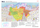
The socio-economic status of households living pre-blast in each zone was estimated by UN-Habitat based on (1) a national ranking of 498 disadvantaged area undertaken to inform the...
Additional Information
| Field | Value |
|---|---|
| Data last updated | August 18, 2020 |
| Metadata last updated | August 18, 2020 |
| Created | August 18, 2020 |
| Format | PNG |
| License | License not specified |
| Has views | True |
| Id | e820ee84-6d26-409e-9ce3-6f93978b17b0 |
| Mimetype | image/png |
| On same domain | True |
| Package id | 527614a2-008d-48ce-9187-f8ce34aad8d2 |
| Position | 2 |
| Revision id | 9e2adce0-54e6-4c60-8a4c-0e5ecbca44cd |
| Size | 30.7 KiB |
| State | active |
| Url type | upload |