thumbnail.png
From the dataset abstract
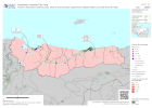
Mapbook shows the number of reported activities per Sector, and who is delivering them, per Municipality in Honduras. Critical and High priority response areas and satellite derived flood...
Additional Information
| Field | Value |
|---|---|
| Data last updated | December 1, 2020 |
| Metadata last updated | December 1, 2020 |
| Created | December 1, 2020 |
| Format | PNG |
| License | License not specified |
| Has views | True |
| Id | c13ebebe-095c-406d-8329-02ea3858c72d |
| Mimetype | image/png |
| On same domain | True |
| Package id | 49242cb5-c642-41c5-a66b-30d495d34588 |
| Position | 1 |
| Revision id | 3121011c-4a70-4813-9ebc-bf0d31eba4d9 |
| Size | 26.5 KiB |
| State | active |
| Url type | upload |