thumbnail.png
From the dataset abstract
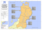
Map showing affected population figures broken down by prefecture together with 2010 National Census figures.
Source: Japan Earthquake and Tsunami Affected Population of Tohoku 12:00 23rd March 2011
Additional Information
| Field | Value |
|---|---|
| Data last updated | July 28, 2016 |
| Metadata last updated | July 28, 2016 |
| Created | July 28, 2016 |
| Format | PNG |
| License | License not specified |
| Has views | True |
| Id | 8050ebcf-f959-4f6a-be66-a25e1d3767b9 |
| On same domain | True |
| Package id | 4e956d37-bc43-4d00-a1a0-d5c074ab142d |
| Position | 2 |
| Revision id | 2a41eb86-551b-475a-8a62-c52b605a5e4f |
| State | active |
| Url type | upload |