thumbnail.png
From the dataset abstract
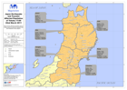
Map showing affected population figures broken down by prefecture together with 2010 National Census figures.
Source: Japan Earthquake and Tsunami Affected Population of Tohoku 17:00 22nd March 2011
Additional Information
| Field | Value |
|---|---|
| Data last updated | July 28, 2016 |
| Metadata last updated | July 28, 2016 |
| Created | July 28, 2016 |
| Format | PNG |
| License | License not specified |
| Has views | True |
| Id | ad2d5d7a-0933-4a63-925c-1ee282e79222 |
| On same domain | True |
| Package id | f6f77e03-9760-4acd-9fc6-744c92223c12 |
| Position | 1 |
| Revision id | ff1776e1-914a-4b48-b86a-3c1090f56f41 |
| State | active |
| Url type | upload |