thumbnail.png
From the dataset abstract
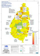
Map shows the location of Water and Sanatation Department (WASCO) reported damage points. Also shown are settlement areas, with approximate population numbers (2001), quarter boundaries,...
Source: Saint Lucia Tropical Cyclone Water & Sanitation Damage (as of 12 Nov 2010)
Additional Information
| Field | Value |
|---|---|
| Data last updated | July 28, 2016 |
| Metadata last updated | July 28, 2016 |
| Created | July 28, 2016 |
| Format | PNG |
| License | License not specified |
| Has views | True |
| Id | 9b13f529-4664-4937-9e1f-9d542343de2e |
| On same domain | True |
| Package id | 4942220d-879b-4fbc-82e4-91fd45d59392 |
| Position | 2 |
| Revision id | e7bb34a4-be38-42c2-8b2f-700a6e2f32a9 |
| State | active |
| Url type | upload |