thumbnail.png
From the dataset abstract
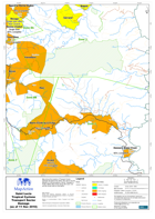
Map shows the location of Transport Sector Damage throughout the island. Also shown are the Ministry of Communications, Works, Transport & Public Utilities Map Zones along with road,...
Source: Saint Lucia Tropical Cyclone Transport Sector Damage (as of 11 Nov 2010) - Map MA016D
Additional Information
| Field | Value |
|---|---|
| Data last updated | July 28, 2016 |
| Metadata last updated | July 28, 2016 |
| Created | July 28, 2016 |
| Format | PNG |
| License | License not specified |
| Has views | True |
| Id | 8a858062-56bc-4014-b890-6594a79edbe0 |
| On same domain | True |
| Package id | 5be679e5-369a-44b3-a4b1-99e55a359b48 |
| Position | 2 |
| Revision id | 64538ca3-3432-4fcf-acc6-828ae38e728b |
| State | active |
| Url type | upload |