thumbnail.png
From the dataset abstract
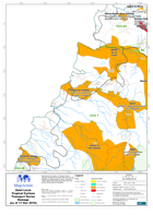
Map shows the location of Transport Sector Damage throughout the island. Also shown are the Ministry of Communications, Works, Transport & Public Utilities Map Zones along with road,...
Source: Saint Lucia Tropical Cyclone Transport Sector Damage (as of 11 Nov 2010) - Map MA016C
Additional Information
| Field | Value |
|---|---|
| Data last updated | July 28, 2016 |
| Metadata last updated | July 28, 2016 |
| Created | July 28, 2016 |
| Format | PNG |
| License | License not specified |
| Has views | True |
| Id | 2e24e5a9-05e5-458c-aa07-ef4b90bff651 |
| On same domain | True |
| Package id | b668043c-e900-4138-b582-e4002346bc16 |
| Position | 2 |
| Revision id | 9a2f7cda-79c7-4ff4-b559-42ca863b3d38 |
| State | active |
| Url type | upload |