thumbnail.png
From the dataset abstract
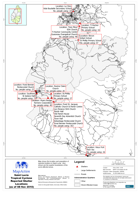
Map shows the location and population of reported shelters in Saint Lucia. Also shown are the quarter boundaries of the worst affected areas.
Source: Saint Lucia Tropical Cyclone Reported Shelter Locations (as of 08 Nov 2010)
Additional Information
| Field | Value |
|---|---|
| Data last updated | July 28, 2016 |
| Metadata last updated | July 28, 2016 |
| Created | July 28, 2016 |
| Format | PNG |
| License | License not specified |
| Has views | True |
| Id | b30ae74b-f52d-4484-9ca5-ee91c5f446e6 |
| On same domain | True |
| Package id | 4b42676f-b2dc-4ed7-a87d-eb5268ccc564 |
| Position | 2 |
| Revision id | 5e433a64-2366-47ac-b16c-2bc6673a4539 |
| State | active |
| Url type | upload |