thumbnail.png
From the dataset abstract
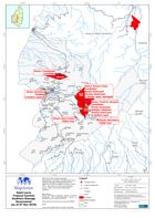
Map shows the localised damage assessment of Soufriere Quarters taken from National Damage Assessment Report #1 dated 30-Oct-2010 & NEMO Sit Rep, 07-Nov-2010. Also shown are the major...
Source: Saint Lucia Tropical Cyclone Soufriere Damage Assessment (as of 07 Nov 2010)
Additional Information
| Field | Value |
|---|---|
| Data last updated | July 28, 2016 |
| Metadata last updated | July 28, 2016 |
| Created | July 28, 2016 |
| Format | PNG |
| License | License not specified |
| Has views | True |
| Id | 45241895-2b03-432e-a9dd-7881b09ab264 |
| On same domain | True |
| Package id | e7a158df-fdc3-48cf-a12a-37bd11396c0a |
| Position | 2 |
| Revision id | 4f32eb2a-3b58-4a04-8be1-5b9895cbc819 |
| State | active |
| Url type | upload |