thumbnail.png
From the dataset abstract
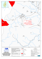
Map shows the localised damage assessment of Dennery North and South Quarters taken fromNational Damage Assessment Report #1 dated 30-Oct-2010. Also shown are the major landslide areas,...
Source: Saint Lucia Tropical Cyclone Dennery North & South Damage Assessment (as of 30 Oct 2010)
Additional Information
| Field | Value |
|---|---|
| Data last updated | July 28, 2016 |
| Metadata last updated | July 28, 2016 |
| Created | July 28, 2016 |
| Format | PNG |
| License | License not specified |
| Has views | True |
| Id | e34f1839-c121-455f-b2bc-583aa0513476 |
| On same domain | True |
| Package id | 33369fa3-e808-4467-bc91-1b74f48324dc |
| Position | 2 |
| Revision id | 58bccba1-2e0f-433e-b83d-c94b672e93f6 |
| State | active |
| Url type | upload |