thumbnail.png
From the dataset abstract
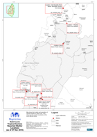
Map shows the location and population of reported shelters in Saint Lucia. Also shown are the quarter boundaries of the worst affected areas.
Source: Saint Lucia Tropical Cyclone Reported Shelter Locations (as of 07 Nov 2010)
Additional Information
| Field | Value |
|---|---|
| Data last updated | July 28, 2016 |
| Metadata last updated | July 28, 2016 |
| Created | July 28, 2016 |
| Format | PNG |
| License | License not specified |
| Has views | True |
| Id | fafe2687-bfe3-48cc-b109-d23882de76c5 |
| On same domain | True |
| Package id | f3218ee2-b38f-4de9-9e97-6f491c536192 |
| Position | 2 |
| Revision id | f4347591-1903-4e69-9a76-ab1836a3fb5d |
| State | active |
| Url type | upload |