thumbnail.png
From the dataset abstract
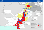
Shows the extent of the flood (2nd Sept 2010) and the numbers of deaths, injured persons, damaged houses and affected population by Province ( 6th Sept 2010).
Source: Pakistan - Flood Extent (2 Sept 2010) and Flood Losses (6 Sept 2010)
Additional Information
| Field | Value |
|---|---|
| Data last updated | July 28, 2016 |
| Metadata last updated | July 28, 2016 |
| Created | July 28, 2016 |
| Format | PNG |
| License | License not specified |
| Has views | True |
| Id | a629a03e-24e2-48d3-b9e0-7ffdfaec7b26 |
| On same domain | True |
| Package id | 35b719ba-584f-4a2c-bfde-194ab4fe63ef |
| Position | 2 |
| Revision id | abe1107c-8089-4c66-8fb6-22710db234f0 |
| State | active |
| Url type | upload |