thumbnail.png
From the dataset abstract
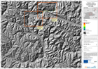
The map indicates possible water depth, in metres, in the event of a catastrophic failure of the landslide dam formed in the Hunza river valley in early January 2010. It is one of a...
Source: Pakistan - Hunza: Lake Outburst Scenario, Overview, Time T0+06hours
Additional Information
| Field | Value |
|---|---|
| Data last updated | July 28, 2016 |
| Metadata last updated | July 28, 2016 |
| Created | July 28, 2016 |
| Format | PNG |
| License | License not specified |
| Has views | True |
| Id | 674ca31b-afd2-4a42-b04f-37da8733930c |
| On same domain | True |
| Package id | 4b3f0bbf-9459-4ff7-874d-33e5cf2b2975 |
| Position | 3 |
| Revision id | 4dfa68d2-ecfd-4fa0-aafd-64d2f041410f |
| State | active |
| Url type | upload |