thumbnail.png
From the dataset abstract
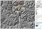
The map indicates possible water depth, in metres, in the event of a catastrophic failure of the landslide dam formed in the Hunza river valley in early January 2010. It is one of a...
Source: Pakistan - Hunza: Lake Outburst Scenario, Overview, Time T0+18hours
Additional Information
| Field | Value |
|---|---|
| Data last updated | July 28, 2016 |
| Metadata last updated | July 28, 2016 |
| Created | July 28, 2016 |
| Format | PNG |
| License | License not specified |
| Has views | True |
| Id | 9496ca8f-7613-4c5b-947e-ed5e48c58f60 |
| On same domain | True |
| Package id | ad1c11fa-dff5-44f7-872d-8f3e21b883e2 |
| Position | 3 |
| Revision id | 767ad39b-c457-4f62-810a-7d21d2d1e2bb |
| State | active |
| Url type | upload |