thumbnail.png
From the dataset abstract
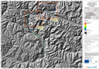
The map indicates possible water depth, in metres, in the event of a catastrophic failure of the landslide dam formed in the Hunza river valley in early January 2010. It is one of a...
Source: Pakistan - Hunza: Lake Outburst Scenario, Overview, Time T0+36hours
Additional Information
| Field | Value |
|---|---|
| Data last updated | July 28, 2016 |
| Metadata last updated | July 28, 2016 |
| Created | July 28, 2016 |
| Format | PNG |
| License | License not specified |
| Has views | True |
| Id | 1711f8ae-7fb2-4861-9b2b-6f69a258408f |
| On same domain | True |
| Package id | 22c44a7c-2582-4d8e-807d-f602ef21a8af |
| Position | 3 |
| Revision id | 048bb0d1-5f80-47d9-8656-3bd536fb5bb6 |
| State | active |
| Url type | upload |