thumbnail.png
From the dataset abstract
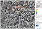
The map indicates possible water depth, in metres, in the event of a catastrophic failure of the landslide dam formed in the Hunza river valley in early January 2010. It is one of a...
Source: Pakistan - Hunza: Lake Outburst Scenario, Overview, Time T0+96hours
Additional Information
| Field | Value |
|---|---|
| Data last updated | July 28, 2016 |
| Metadata last updated | July 28, 2016 |
| Created | July 28, 2016 |
| Format | PNG |
| License | License not specified |
| Has views | True |
| Id | 811da33f-38d1-4e82-aa4b-6dcc926062ed |
| On same domain | True |
| Package id | c4bbd4ee-7fea-4708-8f4e-3dc7013ccab3 |
| Position | 3 |
| Revision id | 4c782f1e-520e-46cb-ba76-7fb2f63643e3 |
| State | active |
| Url type | upload |