thumbnail.png
From the dataset abstract
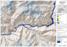
The map is showing the affected areas and the wave progression due to a lake outburst and flooded area.This is expected to follow the landslide that occured on January 4th and which is...
Source: Pakistan - Hunza: Lake Outburst Scenario Map Displaying Flooded Areas. Area 1. T+36.
Additional Information
| Field | Value |
|---|---|
| Data last updated | July 28, 2016 |
| Metadata last updated | July 28, 2016 |
| Created | July 28, 2016 |
| Format | PNG |
| License | License not specified |
| Has views | True |
| Id | b9554db7-5671-459d-a76d-0b414ce562c2 |
| On same domain | True |
| Package id | 30b476e3-7b2d-44b8-81dc-eebbe23c40b6 |
| Position | 3 |
| Revision id | 7f47888c-e639-4776-bd31-7b4bcb2fab6d |
| State | active |
| Url type | upload |