thumbnail.png
From the dataset abstract
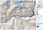
The map is showing the affected areas and the wave progression due to a lake outburst and flooded area.This is expected to follow the landslide that occured on January 4th and which is...
Source: Pakistan - Hunza: Lake Outburst Scenario Map Displaying Flooded Areas. Area 1. T+42.
Additional Information
| Field | Value |
|---|---|
| Data last updated | July 28, 2016 |
| Metadata last updated | July 28, 2016 |
| Created | July 28, 2016 |
| Format | PNG |
| License | License not specified |
| Has views | True |
| Id | 16bad06b-a335-4943-b175-5513f4a9d975 |
| On same domain | True |
| Package id | 12436b38-53c6-41c5-b6c6-fe4c6e35f281 |
| Position | 3 |
| Revision id | 283f572d-e17e-4557-8a11-689f8b4d4491 |
| State | active |
| Url type | upload |