thumbnail.png
From the dataset abstract
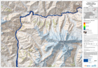
The map is showing the affected areas and the wave progression due to a lake outburst and flooded area.This is expected to follow the landslide that occured on January 4th and which is...
Source: Pakistan - Hunza: Lake Outburst Scenario Map Displaying Flooded Areas. Area 2. T+48.
Additional Information
| Field | Value |
|---|---|
| Data last updated | July 28, 2016 |
| Metadata last updated | July 28, 2016 |
| Created | July 28, 2016 |
| Format | PNG |
| License | License not specified |
| Has views | True |
| Id | 82c57be4-8988-4533-9cff-547a7841f699 |
| On same domain | True |
| Package id | 5e3d8355-2c4f-4beb-846c-de227c287aed |
| Position | 3 |
| Revision id | ebd6355a-4978-41ac-95a4-0ffefd74095a |
| State | active |
| Url type | upload |