thumbnail.png
From the dataset abstract
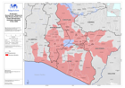
Map showing municipalities reported as affected (Proteccion Civil) and municipalities which have returned EDAN assessment data as of 14 Nov 2009.
Additional Information
| Field | Value |
|---|---|
| Data last updated | July 28, 2016 |
| Metadata last updated | July 28, 2016 |
| Created | July 28, 2016 |
| Format | PNG |
| License | License not specified |
| Has views | True |
| Id | 7dd435b3-8bc5-4987-9cbf-f7187e6f5b0e |
| On same domain | True |
| Package id | 9e154748-9e12-435c-9a2d-e77c4e00aa2f |
| Position | 2 |
| Revision id | 1f7b4a73-421b-4793-b8b2-d9655cd855ab |
| State | active |
| Url type | upload |