thumbnail.png
From the dataset abstract
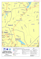
Map shows administrative boundaries at Region and Provincial Level. Basic information on roads, settlement and airfield/ airport have been highlighted.
Source: Philippines: Typhoon Pepeng - Overview map of affected area centered by province.
Additional Information
| Field | Value |
|---|---|
| Data last updated | July 28, 2016 |
| Metadata last updated | July 28, 2016 |
| Created | July 28, 2016 |
| Format | PNG |
| License | License not specified |
| Has views | True |
| Id | 54a7b083-5601-4212-8552-51ab427a9d88 |
| On same domain | True |
| Package id | 25d60b24-26d3-4b20-84ab-5a19a1f8707c |
| Position | 1 |
| Revision id | ff4108f4-ece4-478b-b668-6df425396c32 |
| State | active |
| Url type | upload |