thumbnail.png
From the dataset abstract
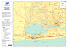
Villages and other localities reported as assessed by Government of Benin by 8 July 2009, and International Federation for Red Cross and Red Crescent (IFRC) by 10 July 2008. Two villages...
Source: Benin: Flooding - Littoral, Atlantique and Oueme Departements: Villages Assessed as of 10 July
Additional Information
| Field | Value |
|---|---|
| Data last updated | July 28, 2016 |
| Metadata last updated | July 28, 2016 |
| Created | July 28, 2016 |
| Format | PNG |
| License | License not specified |
| Has views | True |
| Id | bc850864-9a7f-4f97-b63e-166e8cf51a42 |
| On same domain | True |
| Package id | 1f389765-e204-4845-b501-f51ea2dae414 |
| Position | 2 |
| Revision id | e7c8c879-4f3c-46d2-9415-3201f183024b |
| State | active |
| Url type | upload |