thumbnail.png
From the dataset abstract
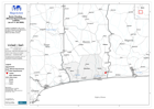
Map shows the Benin Departments affected by flooding as of 11 July 2009. (Black and White version)
Source: Benin: Flooding - Affected Departments In Benin (as of 11 Jul 2009)
Additional Information
| Field | Value |
|---|---|
| Data last updated | July 28, 2016 |
| Metadata last updated | July 28, 2016 |
| Created | July 28, 2016 |
| Format | PNG |
| License | License not specified |
| Has views | True |
| Id | def3c27e-4b4e-40f1-8292-38164cb1d111 |
| On same domain | True |
| Package id | 167921a7-9b9f-458b-b701-ec88690b7deb |
| Position | 1 |
| Revision id | 6b25f510-7b02-4205-bee0-eee6f2bcf545 |
| State | active |
| Url type | upload |