-

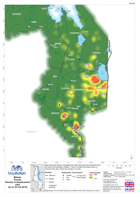
Ebola Outbreak - Quality of Core Services: Referral Centres (as of 3 Sept 2014)
Map shows the status/quality of Referral Centres as of 3rd September, and Reported Cumulative Cases as of 1st September by Administrative levels 1 or 2 . If your... -

Malawi: Floods - Location of Displacement Sites - Blantyre City (as of 17 Feb...
Map shows the location of all reported displacement sites and status. The Displacement Tracking Matrix will update the status of displacement sites. -

Malawi: Floods - Location of Displacement Sites - Machinga (as of 17 Feb 2015)
Map shows the location of all reported displacement sites and status. The Displacement Tracking Matrix will update the status of displacement sites. -
Malawi: Floods - Location of Displacement Sites - Mulanje (as of 17 Feb 2015)
Map shows the location of all reported displacement sites and status. The Displacement Tracking Matrix will update the status of displacement sites. -
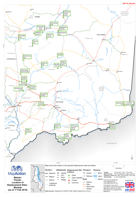
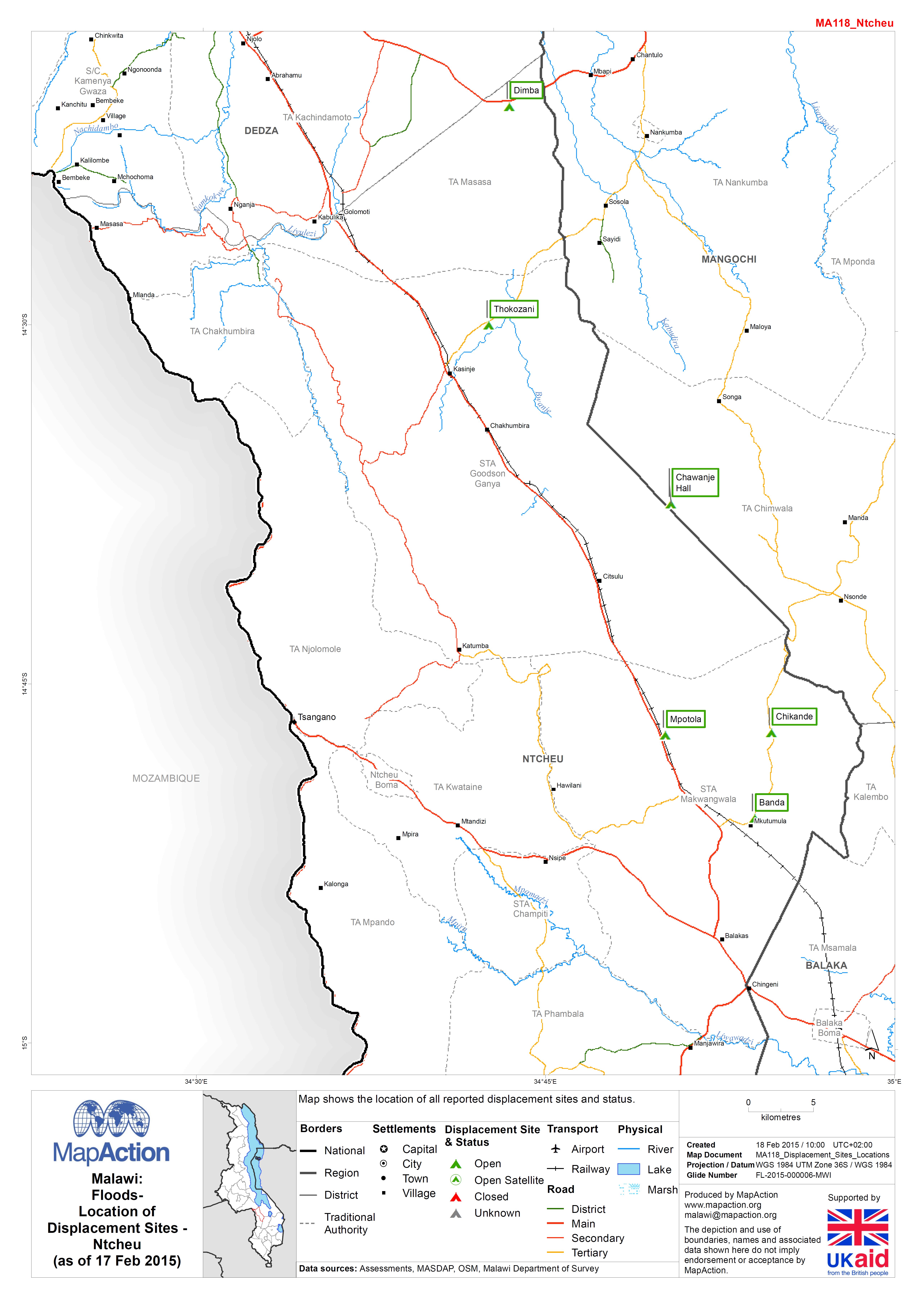
Malawi: Floods - Location of Displacement Sites - Ntcheu (as of 17 Feb 2015)
Map shows the location of all reported displacement sites and status. The Displacement Tracking Matrix will update the status of displacement sites. -
Malawi: Floods - Location of Displacement Sites - Salima (as of 17 Feb 2015)
Map shows the location of all reported displacement sites and status. The Displacement Tracking Matrix will update the status of displacement sites. -

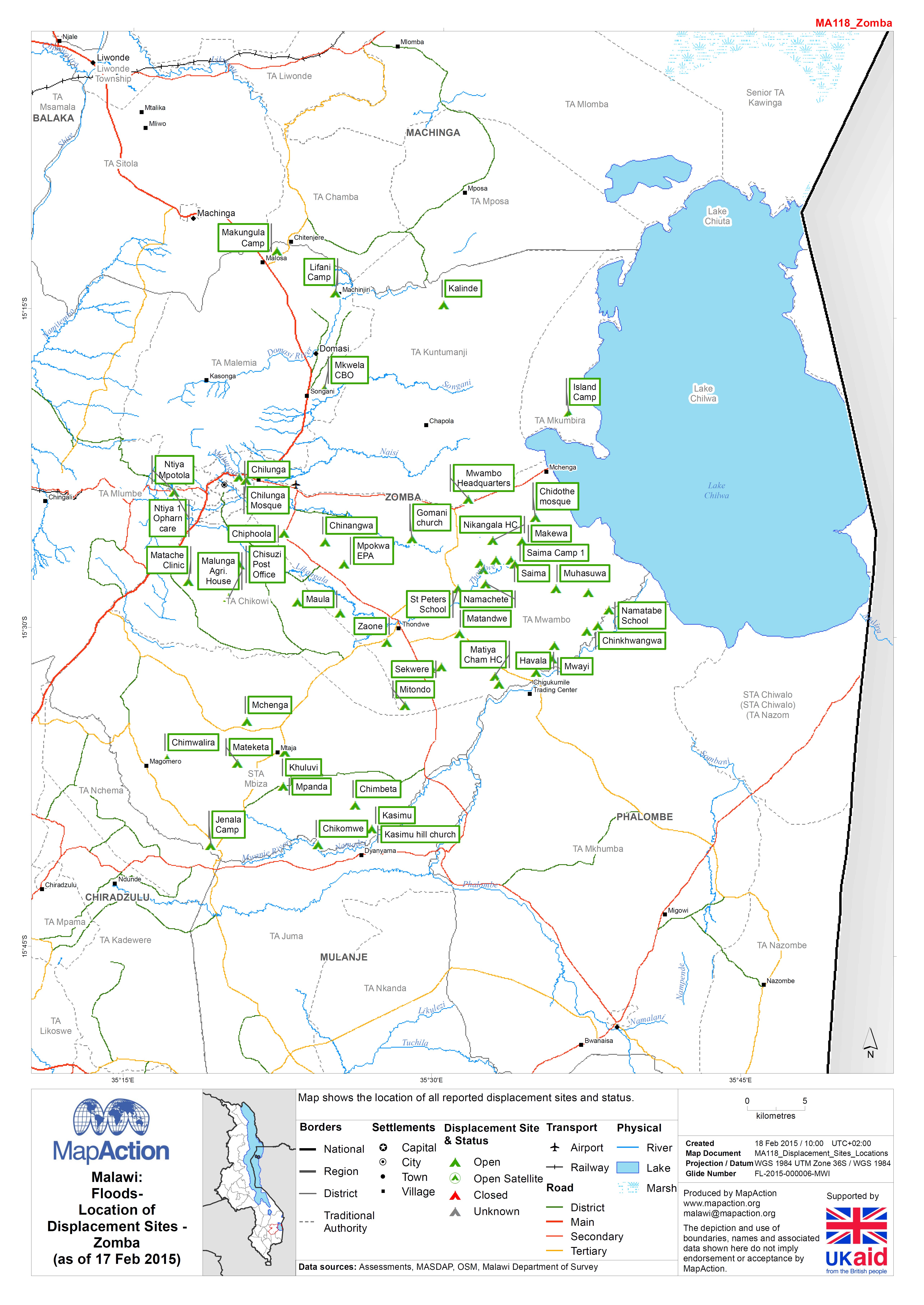
Malawi: Floods - Location of Displacement Sites - Zomba (as of 17 Feb 2015)
Map shows the location of all reported displacement sites and status. The Displacement Tracking Matrix will update the status of displacement sites. -

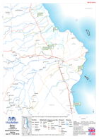
Malawi: Floods - Location of Displacement Sites - Mangochi (as of 17 Feb 2015)
Map shows the location of all reported displacement sites and status. The Displacement Tracking Matrix will update the status of displacement sites. -

Malawi: Floods - Location of Displacement Sites - Phalombe (as of 17 Feb 2015)
Map shows the location of all reported displacement sites and status. The Displacement Tracking Matrix will update the status of displacement sites. -

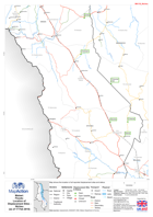
Malawi: Floods - Location of Displacement Sites - Nsanje (as of 17 Feb 2015)
Map shows the location of all reported displacement sites and status. The Displacement Tracking Matrix will update the status of displacement sites. -
Malawi: Floods - Location of Displacement Sites - Thyolo (as of 17 Feb 2015)
Map shows the location of all reported displacement sites and status. The Displacement Tracking Matrix will update the status of displacement sites. -

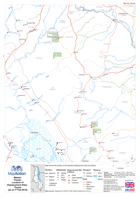
Malawi: Floods - Location of Displacement Sites - Balaka (as of 17 Feb 2015)
Map shows the location of all reported displacement sites and status. The Displacement Tracking Matrix will update the status of displacement sites. -

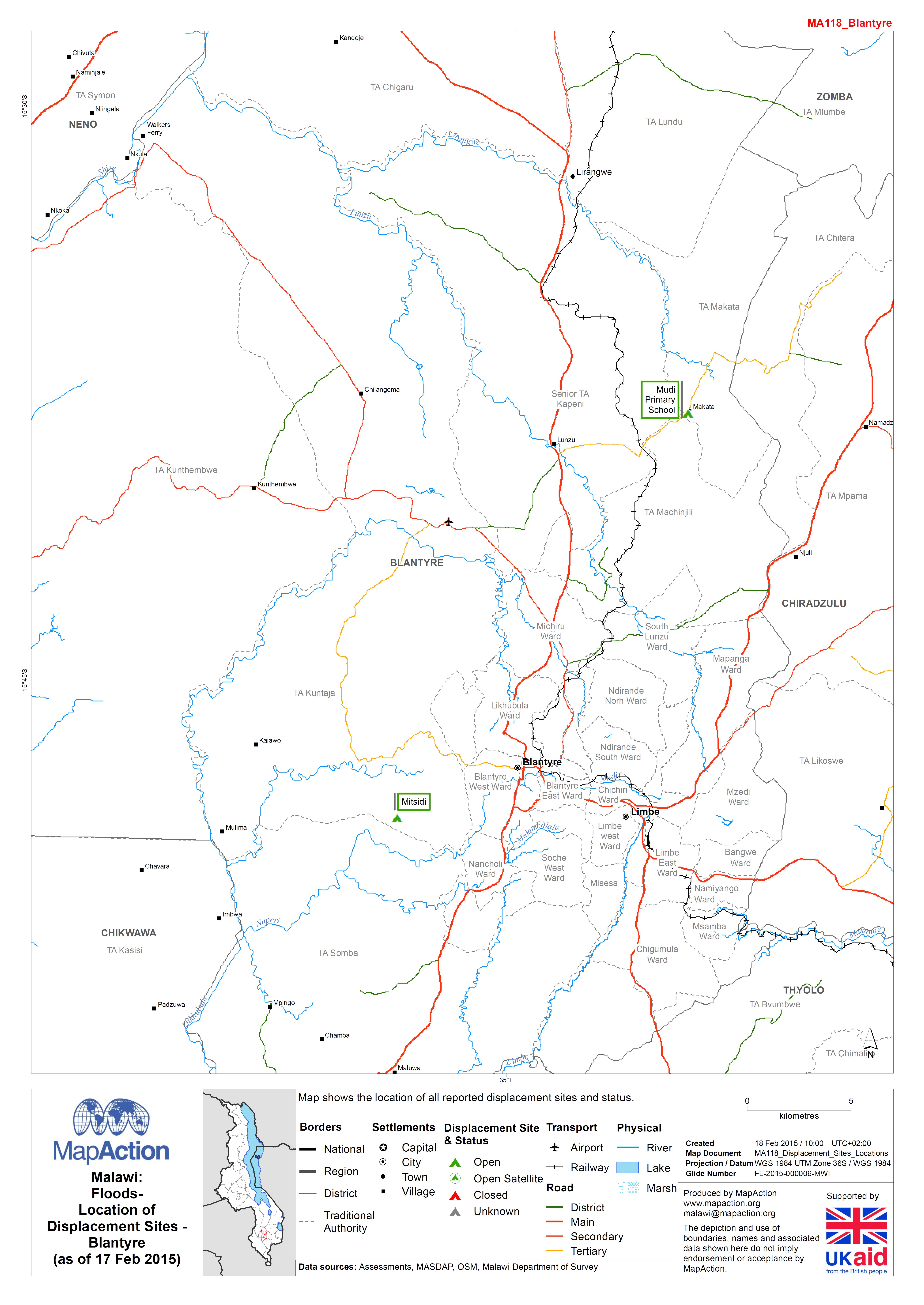
Malawi: Floods - Location of Displacement Sites - Blantyre (as of 17 Feb 2015)
Map shows the location of all reported displacement sites and status. The Displacement Tracking Matrix will update the status of displacement sites. -
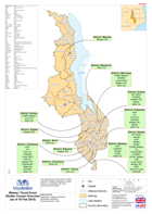
Malawi: Floods-Density of displacement sites(as of 18 Feb 2015)
Map shows the density of displacement sites that have been reported since the start of the flooding in Malawi. It does not reflect the status (open or closed) of the sites... -

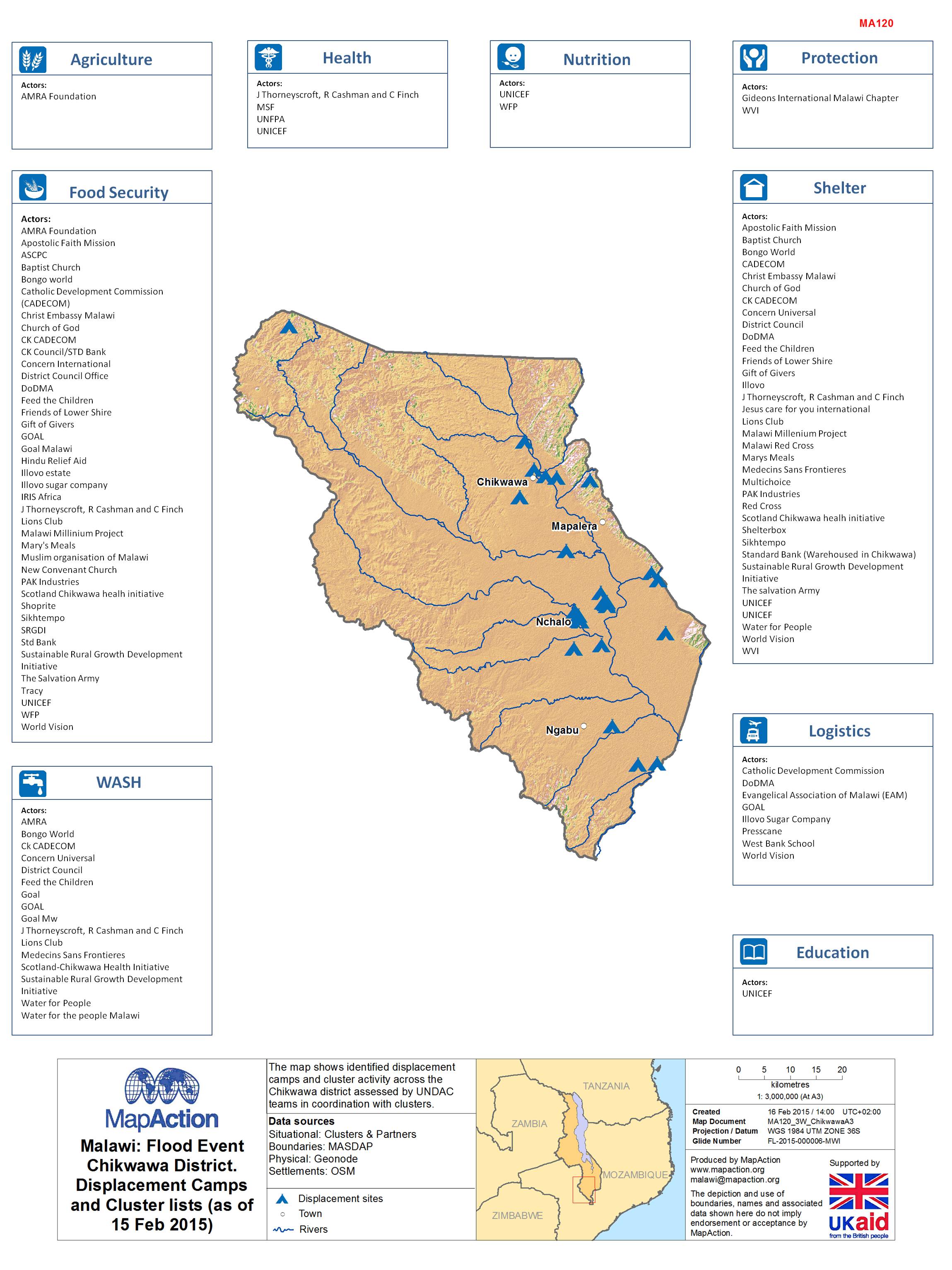
Malawi: Floods - Chikwawa District. Displacement Camps and Cluster lists (as ...
The map shows cluster activity across the Chikwawa district -

Malawi: Floods - WASH Cluster Overview (as of 16 Feb 2015)
The map shows current Actors / NGOs specific to the WASH cluster assessed by cluster teams in coordination with local government in each district. -
Malawi: Floods - Shelter Cluster Overview (as of 16 Feb 2015)
The map shows current actors / NGOs in the Shelter Cluster assessed by cluster teams in coordination with local government in each district. -

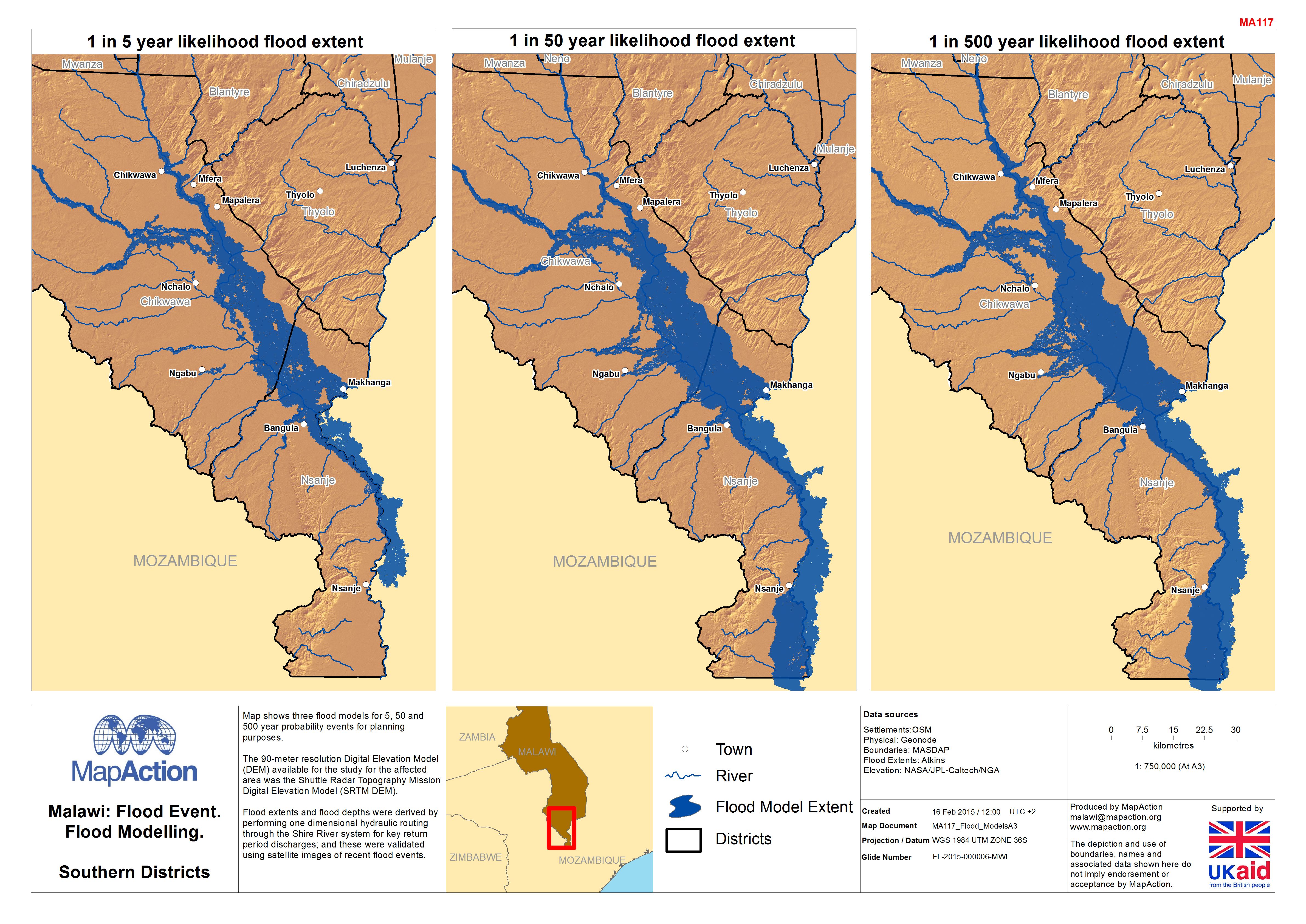
Malawi: Floods - Flood Modelling, Southern Districts
Map shows three flood models for 5, 50 and 500 year probability events for planning purposes. The 90-metre resolution Digital Elevation Model (DEM) available for the study for... -
Malawi: Floods - Flood Extents in Nsanje District (as of 13 Feb 2015)
The map shows known flood extent comparison in the Nsanje district and surrounding areas of Mozambique (derived from MODIS satellite imagery).Data received in Lilongwe for... -
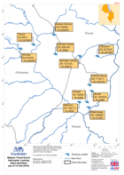
Malawi: Floods Helicopter Landing Sites Identified (as of 13 Feb 2015)
Map shows identified possible landing sites for helicoptors within the Chikwawa, Thyolo and Nsanje districts with co-ordinates added for ease of navigation.Co-ordinates are in...