-

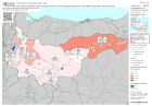
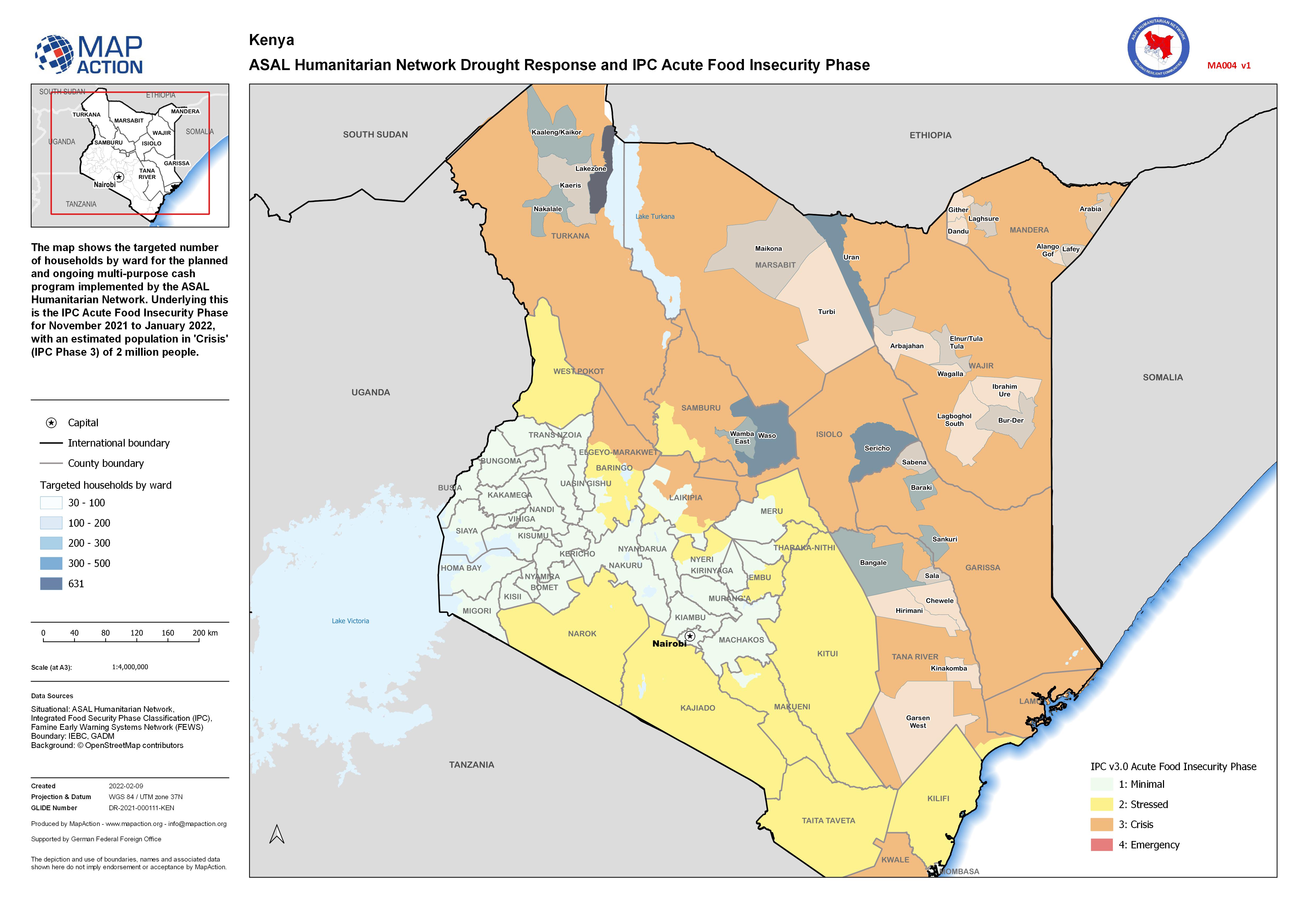
ASAL Humanitarian Network Drought Response and IPC Acute Food Insecurity Phase
The map shows the targeted number of households by ward for the planned and ongoing multi-purpose cash program implemented by the ASAL Humanitarian Network. Underlying this is... -

Presencia humanitaria: quién hace qué, dónde en cada municipio. Departmento: ...
Mapbook shows who is delivering Sector activities, per Municipality in Honduras. Population density, number of shelters and occupants per Municipality -

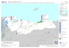
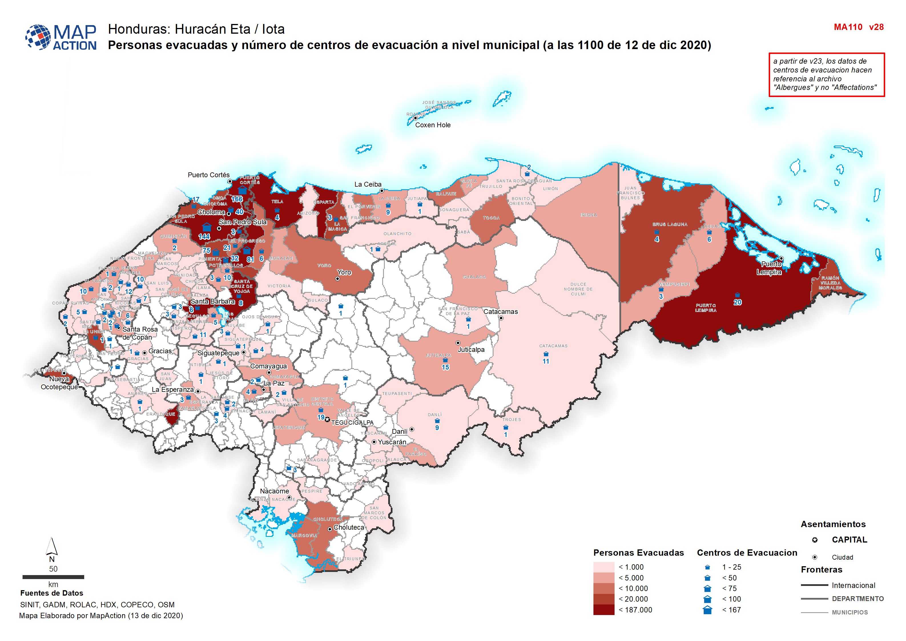
Personas evacuadas y número de centros de evacuación a nivel municipal (a las...
Personas evacuadas y número de centros de evacuación a nivel municipal (a 03 Diciembre 2020 -
Presencia humanitaria: quién hace qué, dónde en cada municipio por department...
Mapbook shows who is delivering Sector activities, per Municipality in Honduras. Population density, number of shelters and occupants per Municipality -

Presencia humanitaria: quién hace qué, dónde en cada municipio, por departmen...
Mapbook shows the number of reported activities per Sector, and who is delivering them, per Municipality in Honduras. Critical and High priority response areas are also shown,... -

Presencia humanitaria: quién hace qué, dónde en cada municipio por department...
Mapbook shows who is delivering Sector activities, per Municipality in Honduras. Population density, number of shelters and occupants per Municipality -

HONDURAS: Presencia humanitaria: quién hace qué, dónde en cada municipio (a l...
Esta serie de mapas muestra quién está realizando actividades por sector y municipio en Honduras. La densidad de población, el número de albergues y su ocupación por municipio... -

Personas evacuadas y número de centros de evacuación a nivel municipal (a 4 d...
Personas evacuadas y número de centros de evacuación a nivel municipal (a 03 Diciembre 2020 -
Presencia humanitaria: quién hace qué, dónde en cada municipio, departmento (...
Esta serie de mapas muestra quién está realizando actividades por sector y municipio en Honduras. La densidad de población, el número de albergues y su ocupación por municipio... -
Presencia humanitaria: quién hace qué, dónde en cada municipio, departmento: ...
Mapbook shows who is delivering Sector activities, per Municipality in Honduras. Population density, number of shelters and occupants per Municipality -
Presencia humanitaria: quién hace qué, dónde en cada municipio, departmento: ...
Mapbook shows the number of reported activities per Sector, and who is delivering them, per Municipality in Honduras. Critical and High priority response areas are also shown,... -

Honduras: Presencia humanitaria: quién hace qué, dónde en cada municipio, dep...
Mapbook shows who is delivering Sector activities, per Municipality in Honduras. Critical and High priority response areas with population density, number of shelters and... -
Honduras: Presencia humanitaria: quién hace qué, dónde en cada municipio, dep...
Mapbook shows the number of reported activities per Sector, and who is delivering them, per Municipality in Honduras. Critical and High priority response areas are also shown,... -

Honduras: Presencia humanitaria: quién hace qué, dónde en cada municipio, dep...
Mapbook shows the number of reported activities per Sector, and who is delivering them, per Municipality in Honduras. Critical and High priority response areas and satellite... -
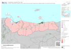
Honduras: Presencia humanitaria: quién hace qué, dónde en cada municipio, dep...
Mapbook shows the number of reported activities per Sector, and who is delivering them, per Municipality in Honduras. Critical and High priority response areas and satellite... -
Who What Where activities / presence at sub-island level as of 13th September...
Who What Where activities / presence at sub-island level as of 13th September 2019 16:30 EDT -

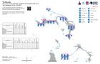
Perú: Temporada de Lluvias - Departamento de Tumbes población / estructuras i...
Las gráficas muestran la población afectada y damnificadas por provincia. Las áreas provinciales están coloreadas por una suma de las viviendas colapsadas e inhabitables al 10... -
Perú: Temporada de Lluvias - Departamento de Ancash población / estructuras i...
Las gráficas muestran la población afectada y damnificadas por provincia. Las áreas provinciales están coloreadas por una suma de las viviendas colapsadas e inhabitables al 6-10... -

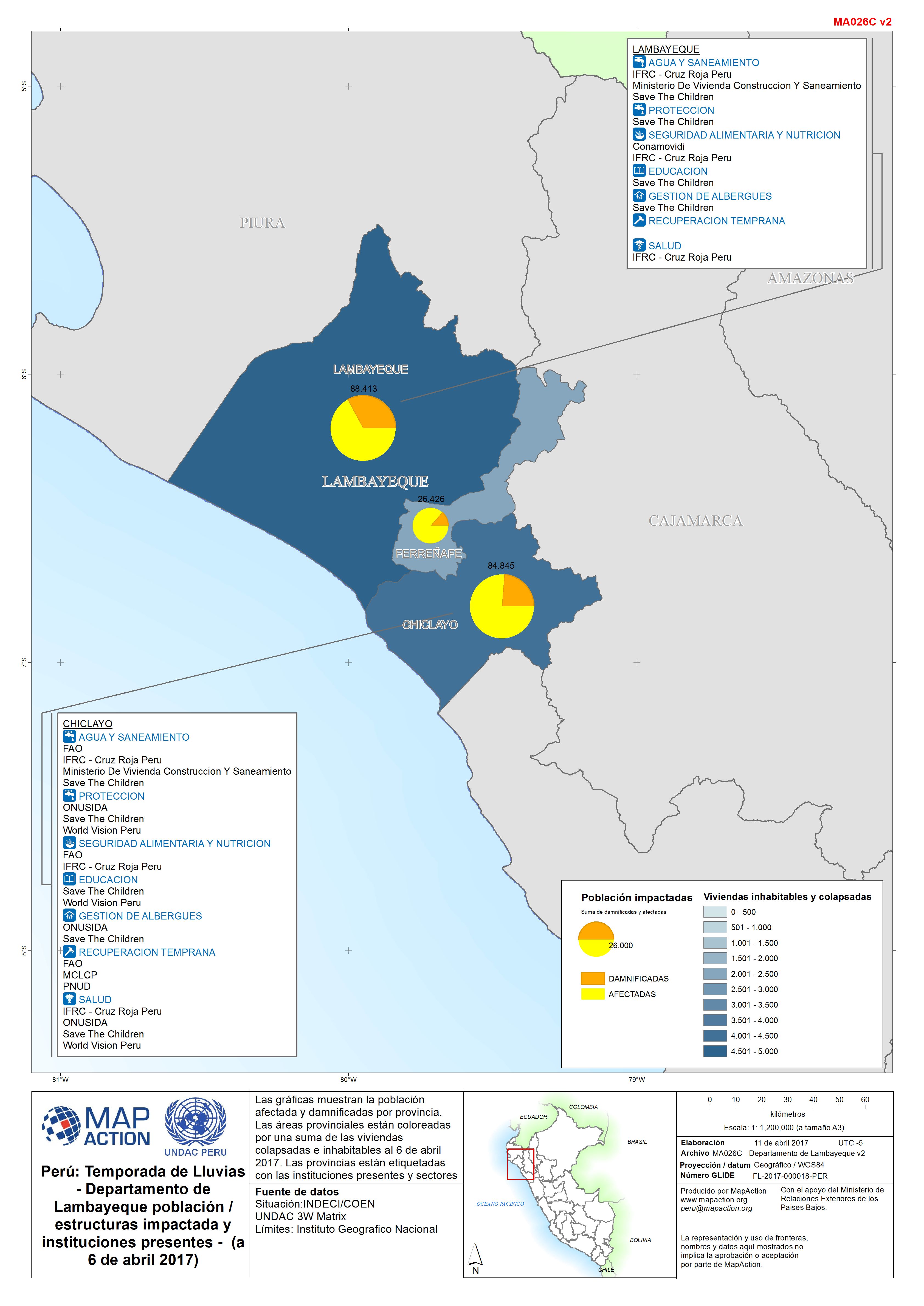
Perú: Temporada de Lluvias - Departamento de Lambayeque población / estructur...
Las gráficas muestran la población afectada y damnificadas por provincia. Las áreas provinciales están coloreadas por una suma de las viviendas colapsadas e inhabitables al 6 de... -

Perú: Temporada de Lluvias - Departamento de La Libertad población / estructu...
Las gráficas muestran la población afectada y damnificadas por provincia. Las áreas provinciales están coloreadas por una suma de las viviendas colapsadas e inhabitables al 11...