-
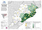
Map shows data for districts in Odisha state, plus one district of Andhra Preadesh. Figures are shown for percentages of district populations as reported by Government (taking...
-
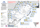
Map shows who-what-where (3W) information on humanitarian responses following Tropical Cyclone Phailin, and further flooding, during October 2013. The map shows relief...
-
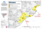
Map shows districts scheduled for needs assessments by Shelter, WASH and Food Security & Nutrition sector groups in Odisha state, beginning week of 11 November. At time of...