thumbnail.png
From the dataset abstract
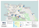
Map shows key operational locations and the activies being conducted at each site. Points of Interest relevant to the operational setting are also provided.
Source: Sierra Leone Landslide/floods - Operations/Logistics (as of 23 Aug 2017)
Additional Information
| Field | Value |
|---|---|
| Data last updated | August 25, 2017 |
| Metadata last updated | August 25, 2017 |
| Created | August 25, 2017 |
| Format | PNG |
| License | Creative Commons Attribution |
| Has views | True |
| Id | 706a5069-8905-49e5-bd6b-3cc7a2376383 |
| On same domain | True |
| Package id | 5dc1caa7-b55c-4381-aba7-2704a296a816 |
| Position | 2 |
| Revision id | 0a80f889-bfe5-4f18-a3f0-50c6d0da9a8a |
| State | active |
| Url type | upload |