thumbnail.png
From the dataset abstract
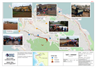
Map indicates the location of active and proposed shelters in Freetown identified by national agencies. Confirmation is needed of the status and population of these shelters.
Source: Sierra Leone Landslide & Floods Shelter Sites as of 23 August 2017
Additional Information
| Field | Value |
|---|---|
| Data last updated | August 26, 2017 |
| Metadata last updated | August 26, 2017 |
| Created | August 26, 2017 |
| Format | PNG |
| License | Creative Commons Attribution |
| Has views | True |
| Id | 4f06b1df-05ee-4ede-ad0b-12f86e0e0158 |
| On same domain | True |
| Package id | f6e398f1-9840-49d7-bd59-88b423300984 |
| Position | 2 |
| Revision id | dabb44d5-535a-439d-973d-ba4ef77fb4a4 |
| State | active |
| Url type | upload |