thumbnail.png
From the dataset abstract
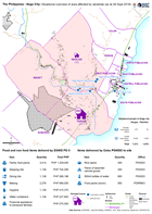
Map shows the affected areas, number of displaced and location of the evacuation centres being used as a result of the landslide to hit Naga city. The table below shows the items of...
Source: The Philippines - Naga City: Situational overview of area affected by landslide (as at 28 Sept 2018)
Additional Information
| Field | Value |
|---|---|
| Data last updated | September 29, 2018 |
| Metadata last updated | September 29, 2018 |
| Created | September 29, 2018 |
| Format | PNG |
| License | License not specified |
| Has views | True |
| Id | ab1ecae3-26a6-41f7-8726-aa8cfe704005 |
| On same domain | True |
| Package id | f1c35794-3909-4b0a-b0da-9e01242a5866 |
| Position | 2 |
| Revision id | bb012b11-956b-4512-8bde-da93fba3b162 |
| State | active |
| Url type | upload |