thumbnail.png
From the dataset abstract
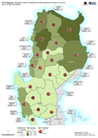
Map shows the reported number of damaged and destroyed houses per province.
Additional Information
| Field | Value |
|---|---|
| Data last updated | September 20, 2018 |
| Metadata last updated | September 20, 2018 |
| Created | September 20, 2018 |
| Format | PNG |
| License | License not specified |
| Has views | True |
| Id | 219bf6b6-1a7b-4d1e-b6c7-0b96ff89d91b |
| On same domain | True |
| Package id | 082f7e18-6940-42c3-8683-d7014b7ce40a |
| Revision id | df6742b3-ab63-4f5a-b3d8-720b5c6f03d5 |
| State | active |
| Url type | upload |