thumbnail.png
From the dataset abstract
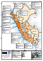
El mapa muestra la afectación por la temporada de lluvias, diciembre 2016 a abril 2017. Actualizado 7 abril 2017 según de la INDECI/COEN.
Additional Information
| Field | Value |
|---|---|
| Data last updated | April 8, 2017 |
| Metadata last updated | April 8, 2017 |
| Created | April 8, 2017 |
| Format | PNG |
| License | License not specified |
| Has views | True |
| Id | 8c8a5568-6ad0-437d-b924-9e1e1765ea97 |
| On same domain | True |
| Package id | db293044-1f67-4873-b412-cce6762f5f8f |
| Position | 2 |
| Revision id | 4876d62e-361e-4c51-83d3-8ea8a3380c2a |
| State | active |
| Url type | upload |