thumbnail.png
From the dataset abstract
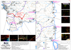
Aerial reconnaissance of the South and South-East of Dominica showing access restrictions and helicopter landing sites. The east coast and south west coast roads are blocked by landslides...
Source: Country: Dominica Emergency: Hurricane Maria Aerial Reconnaissance of South and South-East
Additional Information
| Field | Value |
|---|---|
| Data last updated | September 27, 2017 |
| Metadata last updated | September 27, 2017 |
| Created | September 27, 2017 |
| Format | PNG |
| License | License not specified |
| Has views | True |
| Id | 04d67354-6ceb-4920-b4ab-dac9cbc84972 |
| On same domain | True |
| Package id | 5d3ca32b-7ce7-458d-926c-2bb628d578a7 |
| Position | 2 |
| Revision id | 2a98c6fb-4fd5-4648-aadc-125546cde7dc |
| State | active |
| Url type | upload |