thumbnail.png
From the dataset abstract
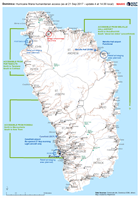
Map of humanitarian access, as reported to the EOC in Roseau up to 14.00 local time on 21 September. This map will change frequently as access conditions change and more information is...
Source: Dominica: Hurricane Maria humanitarian access (as at 21 Sep 2017 - update 4 at 14.00 local)
Additional Information
| Field | Value |
|---|---|
| Data last updated | September 22, 2017 |
| Metadata last updated | September 22, 2017 |
| Created | September 22, 2017 |
| Format | PNG |
| License | License not specified |
| Has views | True |
| Id | 369c1fff-9309-4963-a1b9-63437190522d |
| On same domain | True |
| Package id | 16351748-728e-498a-8d8f-763370f5fd97 |
| Position | 2 |
| Revision id | 9af76227-4b35-41e3-9291-704e45969674 |
| State | active |
| Url type | upload |