thumbnail.png
From the dataset abstract
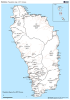
Map of Dominica showing 2011 census total population for each parish and for individual settlements (note that a few census points have not been succesfully identified for mapping).
Additional Information
| Field | Value |
|---|---|
| Data last updated | September 20, 2017 |
| Metadata last updated | September 20, 2017 |
| Created | September 20, 2017 |
| Format | PNG |
| License | License not specified |
| Has views | True |
| Id | befad068-3eb5-4d10-a919-eab9e5435ad4 |
| On same domain | True |
| Package id | 991e59c6-a22f-4f22-a6cb-eaa877f3abd8 |
| Position | 2 |
| Revision id | adeb882f-4d7e-46bf-87f2-12fb308f5499 |
| State | active |
| Url type | upload |