thumbnail.png
From the dataset abstract
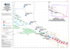
Map showing the track of Hurricane Maria over the Caribbean, their windspeed estimate and forecast path
Source: Caribbean Hurricane Maria Stormtrack (as of 19 Sept 2017, 12:00)
Additional Information
| Field | Value |
|---|---|
| Data last updated | September 20, 2017 |
| Metadata last updated | September 20, 2017 |
| Created | September 20, 2017 |
| Format | PNG |
| License | License not specified |
| Has views | True |
| Id | 0995ab3d-799f-4b4a-9faf-0a450c08769e |
| On same domain | True |
| Package id | c9a1c8a3-a032-4f52-beb0-22526168fae2 |
| Position | 2 |
| Revision id | 029b5133-82f0-4032-b75a-025ca3847569 |
| State | active |
| Url type | upload |