thumbnail.png
From the dataset abstract
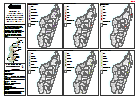
Map shows the impacts of Cyclone Enawo through 6 different indicators - affected population, number of evacuation sites, damaged houses, flooded houses, destroyed houses and houses...
Additional Information
| Field | Value |
|---|---|
| Data last updated | March 19, 2017 |
| Metadata last updated | March 19, 2017 |
| Created | March 19, 2017 |
| Format | PNG |
| License | License not specified |
| Has views | True |
| Id | 9a31ad67-a999-4e0d-b8fe-4366d9c97165 |
| On same domain | True |
| Package id | 4cddb571-eee1-4122-83dd-7f963e0ea502 |
| Position | 2 |
| Revision id | d581493e-a7b6-407f-a8bf-06bbc0841501 |
| State | active |
| Url type | upload |