thumbnail.png
From the dataset abstract
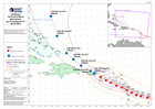
Map showing the track of Hurricane Maria over the Caribbean, with windspeed estimate and forecast path.
Source: Caribbean Hurricane Maria Stormtrack (as of 20 Sept 2017, 06:00 AST)
Additional Information
| Field | Value |
|---|---|
| Data last updated | September 20, 2017 |
| Metadata last updated | September 20, 2017 |
| Created | September 20, 2017 |
| Format | PNG |
| License | License not specified |
| Has views | True |
| Id | 7140bf7c-0b5a-4c59-8c93-c01ed32f1946 |
| On same domain | True |
| Package id | 4dbaf395-3af4-4241-b117-37cbc268d7ed |
| Position | 2 |
| Revision id | eec88096-060a-4c91-aa53-615a16cebd87 |
| State | active |
| Url type | upload |