thumbnail.png
From the dataset abstract
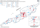
Map shows an overview of the locations assessed by CDEMA for building structure, education and WASH. Assessment areas, ponds, settlements and roads are shown for reference. The numbers...
Source: Anguilla: Hurricane Irma - CDEMA Assessments Locations (as of 13-Sep-2017)
Additional Information
| Field | Value |
|---|---|
| Data last updated | September 16, 2017 |
| Metadata last updated | September 16, 2017 |
| Created | September 16, 2017 |
| Format | PNG |
| License | License not specified |
| Has views | True |
| Id | 99827df4-fe5d-4fb2-87ce-e6deed9d18d9 |
| On same domain | True |
| Package id | e572b500-8a4d-43e6-aabd-96265c54b4ec |
| Position | 2 |
| Revision id | 93eaafff-3843-4618-a322-920160693625 |
| State | active |
| Url type | upload |