thumbnail.png
From the dataset abstract
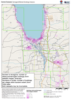
Based on Copernicus imagery analysis, this map summarises the building damage detected in the areas where satellite imagery was captured and processed, and the buildings potentially...
Source: Central Sulawesi Damaged/Affected Buildings Analysis
Additional Information
| Field | Value |
|---|---|
| Data last updated | October 13, 2018 |
| Metadata last updated | October 13, 2018 |
| Created | October 13, 2018 |
| Format | PNG |
| License | Creative Commons Attribution Share-Alike |
| Has views | True |
| Id | 0171d1aa-878d-4a78-b45d-9bd67779aa79 |
| On same domain | True |
| Package id | 59a0f389-92f5-4942-9553-00a3ac976e3a |
| Position | 2 |
| Revision id | 7fbfdf2c-9340-40b5-9a18-8e2b50ccdbab |
| State | active |
| Url type | upload |