thumbnail.png
From the dataset abstract
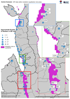
Map shows IDP sites as identified through analysis of Digital Globe imagery from 2nd - 5th October, and areas at risk of liquefaction as determined through the USGS preferred model.
Source: Central Sulawesi: IDP sites within modelled Liquefaction risk areas.
Additional Information
| Field | Value |
|---|---|
| Data last updated | October 10, 2018 |
| Metadata last updated | October 10, 2018 |
| Created | October 10, 2018 |
| Format | PNG |
| License | License not specified |
| Has views | True |
| Id | d7bf5344-b24f-4db1-8e41-413f3b6881de |
| On same domain | True |
| Package id | b49b2016-33cf-40be-a08b-0ea931e883dd |
| Position | 2 |
| Revision id | bde63e69-084e-4b2e-9f4e-0539daa8cb3d |
| State | active |
| Url type | upload |