thumbnail.png
From the dataset abstract
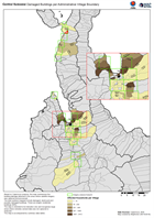
Based on Copernicus analysis, this map summarises the building damage detected in the areas where satellite imagery was captured and processed. The total numbers mapped include damaged,...
Source: Central Sulawesi Damaged Buildings per Administrative Village Boundary
Additional Information
| Field | Value |
|---|---|
| Data last updated | October 9, 2018 |
| Metadata last updated | October 9, 2018 |
| Created | October 9, 2018 |
| Format | PNG |
| License | License not specified |
| Has views | True |
| Id | fcf8faa5-7bcb-4896-969d-c7578c3282a0 |
| On same domain | True |
| Package id | 771e9dd5-6838-4da0-81d7-ddea1a657a91 |
| Position | 2 |
| Revision id | c5ba3b4d-fdf4-4c4a-922e-16aa808c9c53 |
| State | active |
| Url type | upload |