thumbnail.png
From the dataset abstract
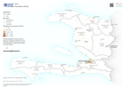
Gridded population density shown is based on Worldpop estimates for 2020. Population totals per province based on 2022 estimates by UNOCHA are listed in province labels
Source: Population density
Additional Information
| Field | Value |
|---|---|
| Data last updated | July 26, 2023 |
| Metadata last updated | July 26, 2023 |
| Created | July 26, 2023 |
| Format | PNG |
| License | License not specified |
| Has views | True |
| Id | b2daa332-8d10-44f4-9157-c94ae0403be1 |
| Mimetype | image/png |
| On same domain | True |
| Package id | f064bab5-2478-4b64-bb25-a3790817e9ae |
| Position | 2 |
| Revision id | c8713da1-c2af-4f63-ae93-0b05ad0b9e62 |
| Size | 14.7 KiB |
| State | active |
| Url type | upload |