thumbnail.png
From the dataset abstract
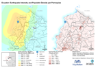
Map shows the earthquake shake intensity - Modified Mercalli Instensity (MMI) scale and the Population density per Parroquia (People per KM2).
Source: Ecuador: Earthquake Intensity and Population Density per Parroquais
Additional Information
| Field | Value |
|---|---|
| Data last updated | May 20, 2017 |
| Metadata last updated | May 20, 2017 |
| Created | May 20, 2017 |
| Format | PNG |
| License | Open Data Commons Attribution License |
| Has views | True |
| Id | 15d5ea59-9fc7-4ef5-81b3-c5313fa396e6 |
| On same domain | True |
| Package id | 35ab4a53-5e47-4a0a-924e-8da6e73b49e5 |
| Position | 1 |
| Revision id | 422f45fc-2f69-412a-bec8-f67ae64c0ff2 |
| State | active |
| Url type | upload |