thumbnail.png
From the dataset abstract
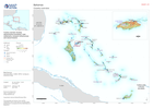
Country overview showing administrative boundaries, main settlements, transport infrastructure and natural features
Source: Country overview
Additional Information
| Field | Value |
|---|---|
| Data last updated | July 26, 2024 |
| Metadata last updated | July 26, 2024 |
| Created | July 26, 2024 |
| Format | PNG |
| License | License not specified |
| Has views | True |
| Id | ebb0fcf4-a629-4b81-abd7-f77e4e8314c4 |
| Mimetype | image/png |
| On same domain | True |
| Package id | 91a81ecb-9383-41c6-aa3d-02fa965796fc |
| Position | 2 |
| Revision id | be5643ea-68a0-437f-a35a-8f8a6fa44af6 |
| Size | 14.5 KiB |
| State | active |
| Url type | upload |