thumbnail.png
From the dataset abstract
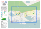
Interpretation of situation in sample areas in selected critical zones as assessed during CDEMA Rapid Assessments conducted 8-11 October 2016 for Government of Bahamas. Spot points...
Source: Bahamas: Hurricane Matthew- Assessment Interpretation
Additional Information
| Field | Value |
|---|---|
| Data last updated | October 24, 2016 |
| Metadata last updated | October 24, 2016 |
| Created | October 24, 2016 |
| Format | PNG |
| License | License not specified |
| Has views | True |
| Id | 3c8ebe25-b29e-45d3-bef8-895baccfbb4b |
| On same domain | True |
| Package id | 620afde7-c751-4c5b-95ad-5b07ea371d43 |
| Position | 2 |
| Revision id | d6df0d56-915a-4f7a-a3b0-1b0a44a872af |
| State | active |
| Url type | upload |