thumbnail.png
From the dataset abstract
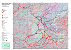
Daily overview map showing known road status and selected towns and localities in affected areas.
Source: Situation overview map
Additional Information
| Field | Value |
|---|---|
| Data last updated | July 4, 2016 |
| Metadata last updated | July 4, 2016 |
| Created | July 4, 2016 |
| Format | PNG |
| License | License not specified |
| Has views | True |
| Id | 04d8ba68-9050-4ef0-821e-599ad8888699 |
| On same domain | True |
| Package id | 161dd7a2-0be8-4ded-b09c-a95dc1e22237 |
| Position | 1 |
| Revision id | d02d87e6-bc75-4c09-a1bd-e418831d0d56 |
| State | active |
| Url type | upload |