thumbnail.png
From the dataset abstract
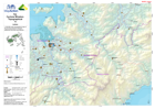
1:100,000 topographical map of Fiji showing physical, transport, settlement and other key features.
Additional Information
| Field | Value |
|---|---|
| Data last updated | July 28, 2016 |
| Metadata last updated | July 28, 2016 |
| Created | July 28, 2016 |
| Format | PNG |
| License | License not specified |
| Has views | True |
| Id | 74be1f43-ea54-482d-a412-30282a81694e |
| On same domain | True |
| Package id | fdf96e26-d361-4347-8402-3fd8701b997d |
| Position | 1 |
| Revision id | a7e0618c-ed4c-4a35-860f-27360052f339 |
| State | active |
| Url type | upload |