thumbnail.png
From the dataset abstract
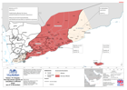
The map shows casualties in the three affected Governates and the Mukalla City District. It also reports on some health facilities affected by cyclone Chapala.
Source: Yemen: TC Chapala - Reports of casualties in affected areas (as of 14 Nov 2015)
Additional Information
| Field | Value |
|---|---|
| Data last updated | July 28, 2016 |
| Metadata last updated | July 28, 2016 |
| Created | July 28, 2016 |
| Format | PNG |
| License | License not specified |
| Has views | True |
| Id | 7bf22ad6-3702-46ab-8dc2-450b399e70bc |
| On same domain | True |
| Package id | 40f3590c-4e2d-4b4c-963a-915c67f6f793 |
| Position | 2 |
| Revision id | adced619-fbe6-4269-92d4-6dd3d20cc338 |
| State | active |
| Url type | upload |